
Territorial dossier
Circuit archéologique & touristique à Kerkennah
Kerkenniens’ historical archaeological circuit, preserved as a heritage framework to document and update.
Explore dossier →Explore
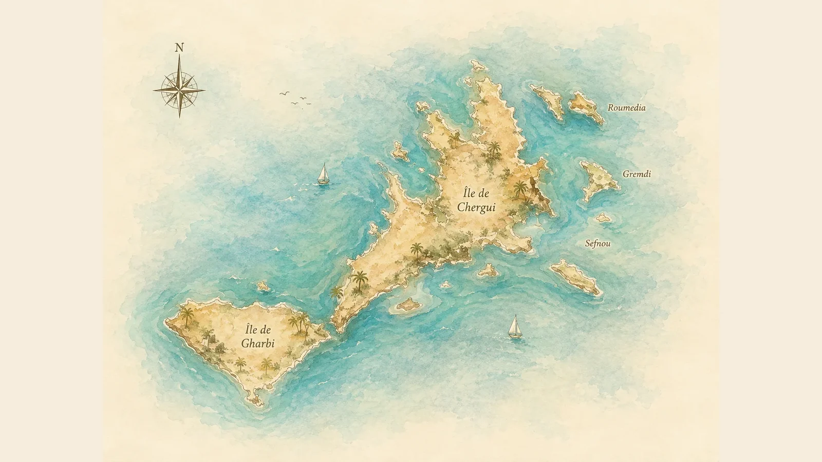
Explore Kerkennah through its main islands, villages and islets. The map provides orientation, the records add context, and the archives let you go further without inventing undocumented facts.
Inhabited territory
Each record separates what the map can locate from what the archives can actually document.
At the western tip of Gharbi, Sidi Youssef is the main maritime arrival landmark. V5 uses it as a gateway connecting crossings, mobility and coastal memory.
Mellita is a major landmark on Gharbi. Kerkenniens archives connect local life, economic activity and territorial reading without claiming to cover the village’s full history.
A landmark on the eastern continuation of Gharbi in the supplied reference maps. Available archives notably document activities related to seafood products.
Sidi Frej appears on the reference maps west of the continuation toward Chergui. It is a useful gateway for coastline, monitoring and coastal-change topics.
Ouled Kacem is positioned in the south-western part of Chergui on the reference maps. Specific documentation still needs consolidation before going beyond this geographic landmark.
Editorial documentation still needs completion. A sourced contribution can enrich this record.
A southern Chergui village, Ouled Yaneg has a richer archival corpus covering fishing-village life, local initiatives, food and everyday life.
Ouled Bou Ali is a central-southern Chergui landmark. Archives provide entry points into family traditions, community life and local development.
Remla, also written Erramla on some maps, is a central Chergui landmark. The site connects it to daily use, the market and services rather than presenting a frozen encyclopedic profile.
Kellabine is visible on the reference maps between Remla and the eastern side. V5 keeps the landmark while explicitly marking its editorial documentation as incomplete.
Editorial documentation still needs completion. A sourced contribution can enrich this record.
El Abbassia is an eastern Chergui landmark. Archives notably connect it to island heritage, the museum and salt landscapes.
Here, Chergui refers to an inhabited landmark and must be distinguished from Chergui Island itself. V5 keeps that distinction to avoid confusing the village and the main island.
Editorial documentation still needs completion. A sourced contribution can enrich this record.
En-Najet appears in northern Chergui on the supplied reference mapping. With no sufficiently solid editorial corpus yet, the page remains deliberately descriptive and open to sourced contributions.
Editorial documentation still needs completion. A sourced contribution can enrich this record.
Kraten is placed at the far north on the supplied maps. Archives connect it to cultural and community initiatives as well as road and landscape stories.
El Attaya lies on Chergui’s eastern side. Available archives notably associate it with port activity and seafood trade.
Around the two main islands
V5 starts with landmarks that can be identified clearly enough from the supplied maps for editorial use.
The western main island of the archipelago. It includes Sidi Youssef and Mellita and is one of the two major island units retained on the simplified home map.
The eastern and northern main island, where many villages and landmarks are located. The home map shows it without towns to avoid suggesting imprecise placement.
An islet identified north-east of Chergui on the supplied reference map. Its position is kept as a cartographic landmark, while its history and uses still require dedicated sources.
An islet east of Chergui on the supplied maps. Kerkenniens already holds archives about Grimdi, providing a basis for a richer profile without extrapolating beyond sources.
An islet marked north-west of Chergui on the supplied reference map. V5 locates it without assigning unverified history or use.
Charmandia is among the small islets listed in the Ramsar information sheet for the Kerkennah Islands. Its record remains deliberately concise until fuller historical and ecological documentation is consolidated.
Lazdad is also listed by the Ramsar sheet among the archipelago’s islets. V5 includes it in the directory without assigning a more precise graphic position than the currently consolidated sources support.
Rakadia, sometimes transcribed Rakkadiya in the literature, is one of the satellite islets cited around Chergui. Spelling variants are retained as a documentary point still to clarify.
The Ramsar sheet mentions the Haj Hmida islets as a distinct group of small island territories. Kerkenniens references them as a group until a finer cartographic breakdown is validated.
Explore with the archive
Maps provide orientation. These dossiers add depth: archaeological circuit, island heritage, saltworks, Grimdi, Fort Lahsar and historical discovery guides.
Territorial dossier
Kerkenniens’ historical archaeological circuit, preserved as a heritage framework to document and update.
Explore dossier →Territorial dossier
A historical gateway to places, sea activities, accommodation, food and curiosities around Kerkennah.
Explore dossier →Territorial dossier
A foundation page on the archipelago, its geography, traditional activities, crafts and food.
Explore dossier →Territorial dossier
The historical dossier of the Abbassya / Dar El Fehri museum, its collections, workshops and transmission role.
Explore dossier →Territorial dossier
El Abbassia saltworks documented as landscape, activity and salt-related heritage.
Explore dossier →Territorial dossier
A field dossier on Grimdi, its landscapes, fragility, biodiversity and island memory.
Explore dossier →Territorial dossier
Fort Lahsar and the archaeological traces around it, to be read through careful and sourced historical context.
Explore dossier →Discover the ecosystem
Tools and services from the same ecosystem, presented with a visual language aligned with Kerkenniens.
 Ecosystem spotlight

Shorten, share and follow what matters without falling into surveillance.
Discover → Ecosystem spotlight

Frame, build, operate and measure digital systems with a structured and auditable approach.
Discover → Ecosystem spotlight

A secure digital envelope to transmit a secret, an access token or sensitive information.
Discover →